
Understanding and predicting climate patterns is a monumental task, and accurate cloud data is crucial to these efforts. David Stanley, a researcher at the University of Illinois Urbana-Champaign, has developed a pioneering cloud imaging program that promises to revolutionize climate models. By employing satellite simulations similar to computed tomography (CT) scans, this program aims to provide a more precise representation of cloud formation and dynamics, significantly enhancing our ability to model climate change. The ability to gather detailed information about clouds and their internal processes could lead to significant advancements in predictive climate science, ultimately contributing to more effective environmental policies and strategies.
Revolutionizing Cloud Imaging
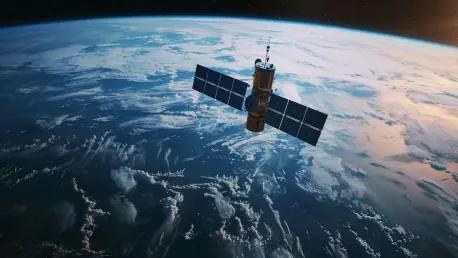
David Stanley’s groundbreaking cloud imaging program captures 3D data of clouds by simulating a coordinated effort of multiple satellites. These satellites take synchronized photos from various angles, much like a CT scan reveals the internal structure of the human body. This technique, referred to as “computed cloud tomography,” enables researchers to delve into the internal dynamics of clouds, something that traditional external cloud observations could never achieve. By capturing comprehensive data, this new approach aims not only to observe cloud formation but also to understand the mechanisms driving them.
The program not only captures the external appearance of clouds but also provides a detailed view of the processes occurring within them. This granular data is invaluable for scientists attempting to understand how clouds develop, dissipate, and influence weather systems over time. By improving the quality and quantity of cloud-related data, the program holds the potential to significantly enhance the accuracy of climate models. Enhanced observations could lead to better predictions about weather patterns, storm formations, and even broader climate shifts, giving researchers a more reliable basis for their models and projections.
Convection and Cloud Dynamics
A pivotal aspect of Stanley’s research focuses on the role of convection—the vertical movement of heat and moisture—in cloud formation and growth. This convection is crucial for understanding how clouds regenerate and contribute to the greenhouse effect. By repeatedly capturing images of cloud centers, the program can track changes in convection and examine their ripple effects on future cloud formation. This allows scientists to study how clouds evolve over time and how they interact with atmospheric components.
This detailed insight into convection processes allows researchers to better understand the lifecycle of clouds. It also provides critical information on how clouds influence atmospheric moisture and temperature gradients, key factors in weather and climate patterns. Such data is instrumental in making more accurate predictions and refining existing climate models. The granularity of data enables a more nuanced understanding of cloud behaviors, offering a more precise foundation for predicting meteorological phenomena and climate variability.
Optimized Satellite Scheduling
Developing the algorithm to optimize the pointing patterns of satellite cameras was a complex but essential task. Stanley used a mixed integer linear programming (MILP) solver to create a scheduler that determines the most efficient timing and angles for the satellite swarm’s cameras. This algorithm ensures that the maximum number of cloud images is captured during each satellite orbit. By optimizing camera angles and timing, the system maximizes data collection without demanding additional resources or satellite adjustments.
By calculating the optimal pointing patterns, the program maximizes the efficiency of satellite missions, enabling more comprehensive data collection without requiring additional resources. This approach aligns with the broader scientific community’s efforts to enhance data accuracy while optimizing resource use. The innovative application of MILP showcases the sophisticated intersection of aerospace engineering, environmental science, and advanced computational methods. It demonstrates how blending different fields of expertise can yield more effective and efficient scientific tools.
Iterative Development and Data Management
The iterative refinement of data management techniques was a critical component of the project’s success. Initially, Stanley divided the Earth’s surface into a grid to target specific indexes for cloud imaging. This method, however, necessitated immense computational power due to the millions of potential target indexes. Taking inspiration from Robyn Woollands’ prior research, Stanley streamlined the system by indexing just the clouds themselves, reducing the computational load dramatically. This efficiency gain allowed the program to manage and analyze vast amounts of data more effectively.
This cloud-centric indexing system significantly improved operational efficiency, making the solution more feasible for real-world applications. The program’s development process underscores the importance of adaptability and continuous improvement in scientific research. By honing the data management approach, Stanley and his team enhanced the program’s capability to capture and analyze cloud data effectively. This refinement process highlights the necessity of flexible strategies in research and the continual quest for better, more efficient methodologies.
Implications for Climate Science
The enhanced 3D cloud data provided by Stanley’s program offers a novel method for visualizing and understanding cloud dynamics. This capability could lead to a better grasp of cloud behavior, positively impacting predictions about climate change and the greenhouse effect. By providing detailed insights into convection and cloud growth, the program stands to improve the accuracy of climate models significantly. These advancements can equip scientists and policymakers with more reliable information, ultimately leading to more informed decisions on environmental action.
Accurate climate models are essential for making informed decisions about environmental policies and mitigating the adverse effects of climate change. Stanley’s innovative approach not only promises better data but also aligns with sustainable practices by optimizing the resources used in satellite missions. The integration of MILP for scheduling highlights the potential for combining engineering and environmental science to achieve significant advancements in climate research. This multidisciplinary approach underscores the importance of innovation in tackling complex global challenges.
Addressing Limitations and Future Directions
Understanding and predicting climate patterns is an enormous task, and having accurate cloud data is key to these efforts. David Stanley, a researcher at the University of Illinois Urbana-Champaign, has made a breakthrough in this field with his innovative cloud imaging program. This cutting-edge program uses satellite simulations akin to computed tomography (CT) scans, aiming to offer a more precise view of cloud formation and behavior. This advancement has the potential to significantly improve our climate models, enhancing our ability to predict climate change. By gathering in-depth information about clouds and their internal processes, this technology could lead to major strides in predictive climate science. Moreover, it holds the promise of contributing to the development of more effective environmental policies and strategies. The implications of Stanley’s work extend beyond academic research; they offer practical benefits that could help societies better prepare for and mitigate the impacts of climate change. In essence, this pioneering approach is set to change how we understand and engage with our changing climate.